Sunday, May 23, 2010

GPS tracks and routes (something I meant to do)

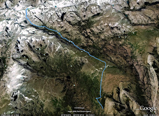
Obviously we are not that on top of this, but I wanted to add the GPS tracks. I know when we were trying to find information it was more difficult than necessary on a lot of the peaks, hills, or mounds. As such I am attaching images of the routes thus far described if we had a GPS track. I attached the GPX files too. The ones in this post are fairly straightforward, but Wheeler and Boundary Peak were a little more complex. There are almost always more than one route to the top, but these ones work. I guess it is silly to say, but don't follow a GPS to your death regardless of where the track goes, or the GPS says you are. Sadly we do not have a file for Whitney since I was using the batteries from the GPS to try and coax a few pictures from our balky camera. This list is in the order we went up more or less, so I will add the rest later as we continue. I may also add failures such as our first attempt at Gannett peak. That might actually be more useful for people.
Mt. Marcy (we hiked up it again later when we had a GPS)
GPX file

Guadalupe Peak (this one is just a trail so pretty easy)
GPX file

Wheeler Peak (New Mexico) - This one has a "trail" from the lake to ridge, but it is less obvious.
GPX file

Humphreys Peak (Arizona)
GPX file

Mt Whitney (no GPS track sorry I used the batteries in my camera)
Since we hiked up the trail (except above the camp) there isn't much to see here anyway.

Boundary Peak (I am not 100% sure that is the way everyone goes, but it works)
GPX file


Kings Peak (Utah) Not much that is tricky besides a part near gunsight notch
GPX file


Black Mesa (Oklahoma) nothing tricky at all
GPX file


The next highpoints were all easy and don't have GPS tracks.  Britton Hill (Florida),  Cheaha (Alabama), Brasstown Bald (Georgia), Mt. Mitchell (North Carolina), Woodall (Mississippi), Mount Magazine (Arkansas), Driskill Mountain (Louisiana), or Mount Davis (Pennsylvania)


Backbone Mountain (Maryland) It can be confusing if you do it at night like we did.
 GPX file


No GPS track for Spruce Knob (West Virginia), Cambell Hill (Ohio), Hoosier High Point (Indiana), Taum Sauk (Missouri), Panorama Point (Nebraska) and none is needed.

Gannett Peak (Wyoming) from the east side, and a failure
From the northwest side and a success.
GPX file failed attempt


GPX file successful attempt done at a later date.


Black Mountain (Kentucky) No GPS track is needed either, but there is one anyway
GPX file


Mount Rogers (Virginia) it is a wilderness area, or so they say.
GPX file


 No GPS tracks for Ebright Azimuth (Deleware), High Point (New Jersey), Clingmans Dome (Tennessee), Sassafras Mountain (South Carolina)

Mount Mansfield (Vermont) no need for a gps track, but here one is.
GPX file


Mount Washington (New Hampshire)
GPX file


Mount Katahdin (Maine)
GPX file


No GPS track Jerimoth Hill (Rhode Island)

Mount Frisell (Connecticut)
GPX file


No GPS track Mount Greylock (Massachusetts)

Mount Elbert (Colorado)
GPX file

Saturday, May 22, 2010

Elbert! Err... Black Mesa

As the end of our time drew near we drove south to Leadville. We planned to hike up mount Elbert. We were on a tight schedule at this point and as we drew closer it began to rain, and rain. We tried to find an internet site, given that this was the dark ages, and eventually called someone on the cell phone to look at the forecast for us. It did not look good. Instead of waiting around for ages and arriving home too late for Tiff to start work we just kept on driving.

We headed along some out of the way routes and it was very late at night as we angled through the top of New Mexico. The road was dirt, instead of pavement as on the map, and completely overrun with wildlife. I almost hit prong-horn, mule deer, and elk. Luckily for them and my car I dodged them all. It was late at night when we arrived. We just camped next to the parking lot. No one was around and it did not seem that anyone minded.
Since we went to sleep well after midnight, morning came quickly, though I actually felt fairly well rested. There was another group who arrived near that time. We started on the hike which follows an old dirt road for most of the way. There were some nice creatures about, both large and small.


The granite monolith makes it seem a bit like a cemetery. At least it is easy to find. Sometimes when the top is so flat like this it takes a bit of effort to figure out just where the top really is.


You can see in the shot below why finding the top might be difficult with no marker, especially back in the days before GPS units were a dime a dozen.


Borah, Where is that again?

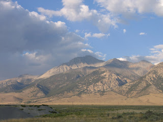
Borah peak the highest mountain in Idaho doesn't seem as though it is in the right spot. It seems the high point should be in the sawtooths instead of the lost river range. With a name like the lost river range you already get the feeling things are a bit confused. There was a large (7.3) earthquake there in 1983 a description is here.

We drove from the pacific coast to the base of Borah. My father, a cousin, a brother's dog, another brother, and a 5 months pregnant sister-in-law accompanied us. Maybe we were a bit confused as well. The hike up is fairly steep. It begins on a nice trail though. This is the type of high point I find entertaining. Straightforward. You go up till you get to the top. No traversing for ages, no up and down on passes, no ridiculously long approach.


You just start hiking up a trail and see some pretty things (especially the dead trees that seemed to be well on their way to petrifying in place) . Then it gets steeper. And you can see the baby bulge now. It seems that would upset your balance. As the trail ends and the hands start being used I had to help the dog.


Just past the picture, while I was holding the dog in my arms (and he weighs like 40 pounds), the dog decided that he had enough. I was stemming across between two ledges and he pushed us away from the cliff face. I imagine he was not intentionally trying to kill us, but instead just get some purchase for his paws. Well I started to drop him so I could grab something before we fell to our death. I managed to keep hold of him with one arm and grab the cliff with the other. To show his gratitude the dog peed on me. At least he was facing the cliff.

My sister-in-law was a bit tired and fell behind as we neared the summit. It is well ingrained in me that safety in the mountains is heavily reliant on the weather. And that it is better to get up and down early. As such Tiffanee and I started taking photos.


She joined us soon though looking only a bit winded. I hope I can do that well when I am 5 months pregnant (er wait a minute :) ).

And I was able to take a lovely picture focusing on a rock. (Note to self check summit picture more carefully after taking it).


Down we went. We made fast time at first, but my dog who was aged and infirm had remained at the campsite near a spring. I felt bad about this and my cousin and I decided to run down the rest of the way. We made it quickly to the campsite and had everything put away by the time the others arrived. My brother explained it took them awhile b/c his wife lost trust in her ability to balance as they hiked down the steep trail. He walked behind her holding the back of her polar fleece in case she ever began toppling forward. There were no ill-effects from this expedition that we know of.


King of the world!

After the quick succession of high points (Texas, New Mexico, Arizona, California, Nevada) and lots of camping Tiff was excited for some down time. I got some shut-eye myself while keeping Tiff occupied. Then my brother decided to try and not get a bike wet.


Finally, recuperated enough, we headed to King's Peak. My dad accompanied us on this trip. It is located in the high uintas. We took the northern approach. When we arrived we talked to a ranger who told us there was no need for ice axes or anything like that since the snow had long since melted.

We got our bags ready and tied our boots. I asked Tiff if she wanted to apply moleskin before we started (since she blisters so easily). She did not. Less than a mile later she decided she did :) Of course by then she had a blister. Somehow finding a boot that does not give her blisters is apparently impossible. Every boot rubs mercilessly on her heel it seems. She was still happy at this point though. She even decided to stalk a moose for photos.


We got to camp relatively early in the day (and this was a mistake). The campsite seemed nice. It was near dollar lake. We went to pump water and found that the mosquitoes were absolutely insane. They were so bad that I ended up putting my shell and mittens on to cover my hands despite it being warm to hot. The lake is also a long way from the summit. Tiff did not want to drink because she did not want to answer the call of nature with all the mosquitoes buzzing about. She also was a bit sick of eating bagels and dried food. I am too lazy to carry a stove usually so I just eat dried food on trips. The sunset was pretty.


The next morning began well and seemed pretty. Kings Peak was already visible as was the notch that some apparently climb and glissade down when there is snow.


Soon Tiff's dehydration and lack of eating started to catch up to her though. She was trudging as we pass up through Gunsight Pass. Luckily we knew not to follow the trail down 600 feet and then immediately back up. Instead there was a track that angled off to the south and then west and avoided dropping down. Even then by the time we reached the plateau on the other side she was really done in. Of course when you have hiked more than 10 miles and are over 12,000 feet it is hard to turn around. Eventually we decided to leave her pack and head for the top once the summit ridge angled south from a small saddle.

We made better time then. We went so fast in fact that we caught up an an 80 year old man. Yes that is right. Sure makes you feel a bit silly when you are tired. He had been up most of the high points, but was missing Kings Peak and Gannett Peak. He was actually about to turn around and head down. I showed him my GPS so he could see just where he was. We were less than 200 vertical feet from the summit. It was hard to tell otherwise because as ridges often do this one makes it tricky to determine just how much farther you need to go until you get to the top. He was very happy to see this. With the extra motivation only an 80 year old can give we all reached the summit. Tiff was ecstatic that the old guy has some chocolate which he shared with the rest of us. (Note to self bring chocolate on hikes in the future ).


It was a long way back down to the car. We walked and walked, and trudged, and limped. Tiff threw up, got heat rash, and gritted her teeth as my dad and I complained about stone bruising on our feet. Finally we got to the car and took off our heavy boots. Tiff began to cry at this point. She had blisters all over her heels, on the side of her big toe, between her toes, under her toes, under the ball of her foot, on the arch, and under her nail as well. At least there were no blisters on top. I never saw someone get a blister under the nail before, but she did. Eventually she lost the nail as well. So that stone bruising my dad and me were complaining about, it wasn't so bad.
At least we had salt and vinegar pringles in the car. That made Tiff happy again. I suppose it is the simple things after all, salt, sugar, and fat.